By: FlySafe Research
A coalition of aviation safety stakeholders has called on the Federal Aviation Administration to evaluate the risks posed by slacklines and similar temporary obstructions strung across navigable airspace. The request raises a question that has long concerned rotorcraft operators and low-altitude aviators: whether existing regulatory frameworks adequately address thin, difficult-to-see lines suspended at altitudes frequented by helicopters, air ambulances, and agricultural aircraft. FlySafe analysis shows that this issue sits at the intersection of recreational activity and airspace safety — a gap that warrants close attention from pilots, operators, and regulators alike.
The Obstruction Problem in Low-Altitude Airspace
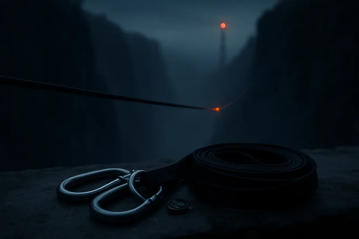
Slacklines — narrow webbing lines tensioned between anchor points for recreational balancing — have grown substantially in popularity over the past decade. Highlines, a subcategory rigged across canyons, gorges, and between structures, can span hundreds of meters at altitudes that overlap directly with low-level flight operations. Unlike permanent obstructions such as towers, buildings, or powerlines, slacklines are temporary, often unmarked, unlighted, and not reported to any aviation authority.
This matters because low-altitude flight is already among the most hazardous phases of aircraft operation. Research published in MDPI's Safety journal confirms that low-level flight or maneuvering is "particularly common and, in some cases, central to helicopter operations, but brings several safety concerns." At low altitude, helicopters face heightened susceptibility to collisions with objects, while time and space for emergency response remain severely limited. A study of 403 helicopter accidents in the low-level flight regime underscores the statistical significance of this exposure.
The coalition's petition to the FAA focuses on whether current obstruction marking, lighting, and notification requirements — designed primarily for permanent structures — are sufficient for a new generation of temporary, near-invisible hazards.
Wire and Cable Strikes: A Directly Analogous Hazard
The aviation community does not lack data on what happens when rotorcraft encounter thin, hard-to-see lines in flight. According to helicopter safety statistics compiled by Gitnux, wire and powerline strikes account for approximately 10% of global helicopter accidents. This figure represents one of the most persistent categories of rotorcraft mishaps worldwide, and it has remained stubbornly resistant to reduction despite decades of safety campaigns, wire-strike protection systems, and improved charting of powerline locations.
Slacklines present a comparable — and in some respects more challenging — detection problem. Powerlines, while thin, are at least mapped, generally permanent, and often accompanied by visible towers or poles. Slacklines, by contrast, can appear and disappear within hours, are typically rigged without any notification to aviation authorities, and are composed of materials with negligible radar reflectivity. They carry no lighting, no marking, and no charted position.
The US helicopter industry has made significant safety progress in recent years. Data from the Vertical Aviation International (VAI) 2024 annual review indicates that the US helicopter sector posted its lowest number of fatal accidents (13) and its lowest fatal accident rate (0.44 per 100,000 flight hours) in 25 years. The overall accident rate of 2.99 per 100,000 flight hours was similarly the lowest in a quarter century. A 77-day streak with no fatal accidents occurred between February 9 and April 26, 2024 — the longest such streak since 2020.
These gains, however, could be partially offset if new categories of unmarked obstructions proliferate in the low-altitude environment without corresponding regulatory adaptation. The coalition's position is that slacklines represent exactly this kind of emerging, unaddressed risk.
NOTAM Coverage and Notification Gaps
A central element of the coalition's request concerns the Notice to Air Missions (NOTAM) system and whether it can or should be used to communicate the presence of temporary obstructions like slacklines.
The FAA's NOTAM infrastructure has undergone significant modernization. As reported by Aerotime, the FAA launched the first phase of its new NOTAM Management Service (NMS) on September 29, 2025, a cloud-based platform designed for resilience and near-real-time data sharing. The system replaced a legacy platform dating back to 1985, the failure of which in January 2023 caused a nationwide ground stop affecting more than 11,000 flights. Full migration of more than 12,000 global users is scheduled for completion by late spring 2026.
The modernized NMS presents NOTAMs in plain language rather than the legacy format's difficult-to-interpret acronyms, according to FLYING Magazine. With over 4 million NOTAMs issued annually, the system's capacity to handle additional obstruction notifications is a relevant operational question.
However, the practical challenge remains: slackline rigging is typically conducted by private individuals on public or private land, with no existing requirement to notify the FAA. Unlike crane operations, construction activities, or temporary tower erections — which trigger obstruction notification requirements under 14 CFR Part 77 — recreational slackline installations fall into a regulatory gap. No filing obligation exists, no permit is required in most jurisdictions, and the participants may have no awareness that their activity intersects with navigable airspace.
Airspace status: Under current regulations, temporary obstructions below 200 feet AGL on private property generally do not require FAA notification. Many highline installations in canyon and gorge environments, however, can span altitudes well within the operational envelope of helicopter emergency medical services (HEMS), search and rescue, law enforcement, firefighting, and agricultural operations.
Affected Operations and Routes
The concern is not theoretical. Low-altitude rotorcraft operations are concentrated in precisely the terrain where highline and slackline activity is most prevalent: mountainous areas, river gorges, canyon systems, and national parks or recreation areas.
Affected routes: Helicopter air ambulance corridors, wildfire suppression routes, power-line patrol paths, and agricultural spray operations frequently traverse terrain where recreational slackline activity occurs. Search and rescue helicopters operating in canyon environments face particular exposure, as these are simultaneously popular locations for highlining.
The US Helicopter Safety Team (USHST) maintains ongoing safety reporting and data dashboards tracking rotorcraft accident trends. The organization's vision — "a civil helicopter community without fatal accidents" — depends in part on the identification and mitigation of emerging hazard categories before they contribute to the accident record.
Recommendation: Operators conducting low-altitude missions in mountainous or canyon terrain should incorporate awareness of potential slackline obstructions into their operational risk assessments, particularly in areas known for recreational highline activity.
What the Coalition Is Requesting
Based on publicly available information, the coalition's petition to the FAA encompasses several specific areas of review:
Marking and Lighting Standards
Whether the FAA should establish visibility requirements for slacklines and similar temporary obstructions installed at altitudes that intersect with navigable airspace. Current Advisory Circular guidance on obstruction marking and lighting (AC 70/7460-1) addresses permanent and semi-permanent structures but does not contemplate recreational lines.
Notification Procedures
Whether a streamlined NOTAM or obstruction-reporting mechanism should be created for temporary recreational obstructions. The modernized NMS platform, with its cloud-based architecture and plain-language format, could potentially accommodate such notifications — but only if a reporting obligation or voluntary reporting pathway is established.
Coordination with Land Management Agencies
Many highline installations occur on federal lands managed by the National Park Service, Bureau of Land Management, or US Forest Service. The coalition has suggested that interagency coordination could address the notification gap by requiring permits for highline installations that include an FAA notification component.
Industry Stakeholder Engagement
How the FAA should coordinate with industry stakeholders — including helicopter operators, air ambulance services, agricultural aviation associations, and the recreational slackline community — to develop practical hazard mitigation measures.
Practical Guidance for Pilots and Operators
Until regulatory clarity emerges, FlySafe recommends the following operational considerations:
Pre-flight planning: When operating in canyon, gorge, or mountainous terrain popular with recreational users, assume the possible presence of unmarked slacklines at various altitudes. Cross-reference known recreational areas with planned flight routes.
Speed and altitude management: In areas of elevated obstruction risk, reduced airspeed provides additional reaction time. Where operationally feasible, altitude selection should account for potential obstructions not depicted on charts.
Crew awareness: For multi-crew operations, briefing on the potential for unmarked temporary obstructions in the operating area enhances collective situational awareness.
Reporting: Pilots who observe slacklines or similar obstructions in navigable airspace should report them through the FAA's safety reporting channels. Voluntary reports contribute to the data foundation necessary for regulatory action.
Based on publicly available NOTAMs, no specific TFRs or airspace restrictions have been issued in relation to slackline installations at the time of publication. The coalition's request remains under FAA review.
Key Takeaway
The growth of recreational highlining introduces a category of temporary, unmarked, and unreported obstructions into low-altitude airspace. With wire and cable strikes already accounting for an estimated 10% of global helicopter accidents, the emergence of additional thin-line hazards in terrain frequented by rotorcraft operations represents a credible safety concern. The coalition's petition to the FAA highlights a genuine regulatory gap — one that exists between recreational freedom and aviation safety requirements.
FlySafe will continue to monitor FAA proceedings on this matter and update airspace risk assessments as regulatory guidance develops. Operators and pilots are encouraged to consult current NOTAMs and local area advisories before conducting low-altitude operations in terrain where recreational obstruction activity may be present.
Analysis based on publicly available data only. FlySafe Research does not possess or utilize classified or non-public information.
Frequently Asked Questions
Are current marking and lighting requirements sufficient for temporary obstructions like slacklines in navigable airspace?
Current FAA obstruction marking and lighting standards under AC 70/7460-1 were designed for permanent or semi-permanent structures such as towers, buildings, and cranes. Temporary recreational installations like slacklines fall outside the scope of these requirements, which is the core of the coalition's concern. No marking, lighting, or visibility standard currently applies to recreational lines rigged across navigable airspace.
What pilot-notification procedures currently exist for temporary low-altitude obstructions, and are they adequate?
The NOTAM system provides the primary mechanism for communicating temporary hazards to pilots. However, slackline installations carry no FAA notification requirement, meaning they are invisible to the NOTAM system entirely. The coalition argues that a voluntary or mandatory reporting pathway is needed to close this gap, particularly given the FAA's modernized NMS platform now supports near-real-time data sharing.
What specific measures can reduce accidents from temporary obstructions in low-altitude airspace?
Industry data indicates that wire and cable strikes account for roughly 10% of global helicopter accidents despite existing mitigation measures. For temporary obstructions, a combination of reporting requirements, interagency coordination with land management authorities, and pilot awareness campaigns represents the most practical near-term approach. Longer-term solutions may involve integration of temporary obstruction data into electronic flight bags and cockpit avionics.
- Slacklines rigged at canyon or structure heights create a near-invisible obstruction hazard in low-altitude airspace — unlike powerlines, they are temporary, unmapped, unlighted, and entirely outside existing FAA reporting requirements.
- Wire and powerline strikes already account for roughly 10% of global helicopter accidents, and slacklines present an even harder detection problem since they lack the visible poles or charted routes that at least partially mitigate powerline risk.
Powered by B1KEY
Live tools behind the analysis.
The signals FlySafe writes about are also published live — continuously verified by the Sentinel pipeline.
Information is accurate as of the publication date. FlySafe uses exclusively publicly available data.