Fuego Volcanic Ash — Aviation Impact, November 2026: Advisories Every Day Since 20 October, Ash SFC/FL150 Drifting West, an Observed Ash Area Over Guatemala City (GUA) on 28 October — 1 of 742 on Record
- Fuego is in a steady ash run: an advisory roughly every six hours since 20 October, 50 in all, each carrying ash. The latest, 04:19 UTC on 1 November, reports ash from the surface to FL150 moving west at 15 kt. Fuego is a persistent emitter — a bulletin on 174 of the 175 days since our record began on 11 May — not a volcano in a single new eruption.
- On 28 October an observed ash area covered Guatemala City's airport (GUA) — the first of 742 observed areas since 11 May to do so. It was low ash, surface to FL140, moving east at 5 kt and seen on satellite at 10:10 UTC; by 15:40 UTC it had moved clear, and every area since has stayed 35 km or more away. The airport's weather reports carried no volcanic ash, and observed traffic that day was the busiest Wednesday of October.
- The ash is drifting west again. Every advisory since early 29 October has it moving south-west or west. Retalhuleu (RER) sits inside two forecast areas for today in the 22:28 UTC 31 October advisory; the 04:19 UTC forecasts stop about 25 km short. San José (GSJ), 60 km south of the vent, was inside observed areas on 27 and 28 October.
- Ash tops are FL140–FL160 — far below the cruise levels of traffic crossing Central America. They matter for arrivals, departures and low-level flying near the volcano.
- Observed traffic at GUA averaged 344 movements a day across the settled days 20–28 October, 10% above its 1–19 October mean. Our data does not tie the traffic to the volcano. Check your airline on the day of travel.
Advisory timeline — how active is this episode
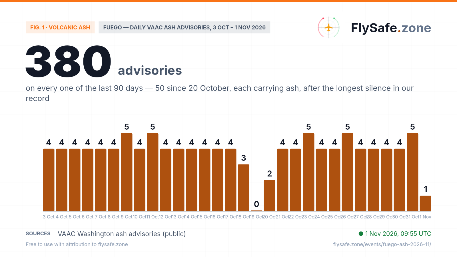
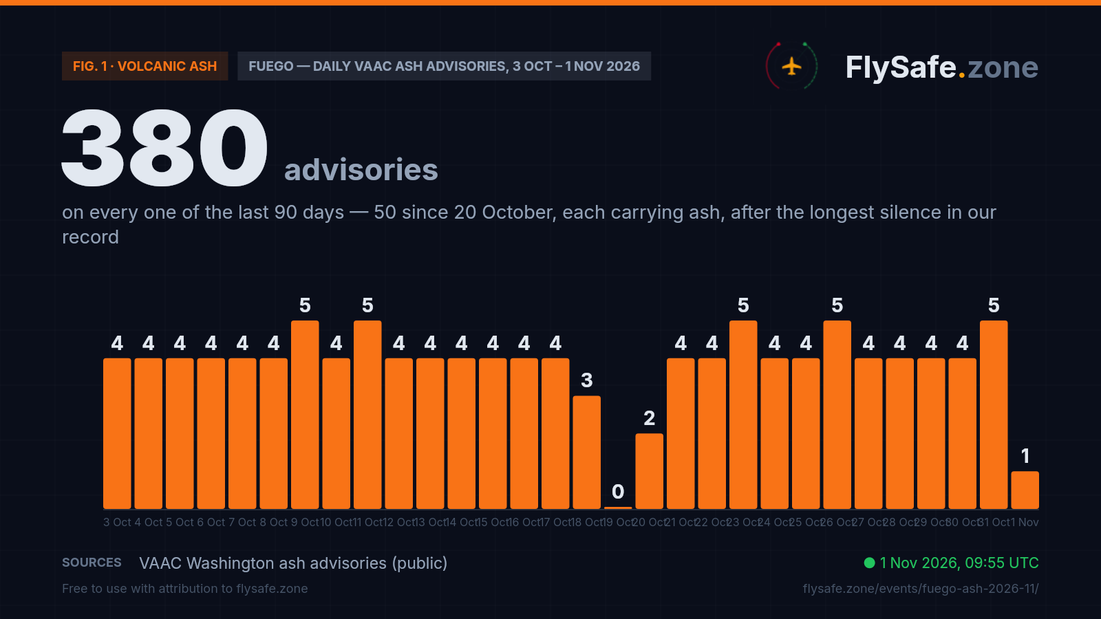
Fuego is a persistent emitter: VAAC Washington has issued 380 ash advisories over the last 90 days, at least one on every day, and 735 bulletins since 11 May, when our advisory collection begins — so every count here is a floor on the volcano's history, not its start. Since 11 May there has been a Fuego bulletin on 174 of 175 days. The October page closed on the no-ash bulletin of 00:30 UTC on 10 October; 6.6 hours later, at 07:06 UTC, the advisories resumed with an ash cloud seen on satellite drifting south-west, and 34 ash-bearing advisories followed to 18 October. A no-ash bulletin at 13:10 UTC on 18 October then opened a 49-hour silence, to 13:57 UTC on 20 October — the longest gap between Fuego bulletins in our record, four times the next-longest (12 hours, 29 September), and the reason 19 October is the one empty bar. It was the volcano's own silence, not a hole in the feed: VAAC centres issued 90 advisories for 13 other volcanoes in that window. Since 13:57 UTC on 20 October there have been 50 Fuego advisories, every one carrying an ash area — four or five a day from 21 October. VAAC Washington's advisory numbers run without a gap from 2026/1177 on 9 October to 2026/1266 this morning, so no bulletin of that stretch is missing from our record. The bars count every bulletin, including the no-ash bulletins of 10 and 18 October and the 9 October advisory re-issued seven minutes later with a corrected flight-level remark. 3–9 October is covered on the October page; 1 November is a partial day. Daily advisory count, 3 October – 1 November:
Fig. 1 — Fuego daily VAAC ash advisory count, VAAC Washington (public) · * partial day · Data as of 1 Nov 2026, 09:55 UTC · Source: VAAC Washington ash advisories (public).
Airports in the exposure zone
| Airport | Size | Distance from vent | FIR |
|---|---|---|---|
| La Aurora International (GUA) | large | 40 km · east-north-east — inside 1 of 742 observed and 1 of 2,089 forecast ash areas on record since 11 May, both in the 10:51 UTC 28 Oct advisory (observed 10:10 UTC, airport ~3 km inside the edge; 16:00 UTC forecast ~2 km inside); 35 km or more from every observed edge since 16:01 UTC 28 Oct | MHCC |
| San José (GSJ) | medium | 60 km · south — inside the observed areas of the 17:08 UTC 27 Oct and 16:01 UTC 28 Oct advisories during the southward drift, and inside four forecast areas since 10 Oct; 3 of 742 observed areas on record (30 Sep, 27 Oct, 28 Oct) | MHCC |
| Retalhuleu (RER) | medium | 88 km · west — no observed area since 16 Sep (32 of 742 on record); nearest observed edge since 10 Oct ~10 km (07:37 UTC 21 Oct), ~15 km at 22:28 UTC 31 Oct; inside the 10:00 and 16:00 UTC 1 Nov forecast areas of the 22:28 UTC 31 Oct advisory; ~25 km from the 04:19 UTC 1 Nov forecasts | MHCC |
| Tapachula International (TAP) | medium | 164 km · west-north-west, Mexican side — outside every observed and forecast area since 10 Oct; nearest observed edge ~74 km (16:43 UTC 31 Oct, the run's widest area); 3 of 742 observed areas on record (11 Aug, 12 Sep) | MMFR |
| Ilopango International (ILS) | medium | 209 km · east-south-east — outside all 742 observed and 2,089 forecast ash areas on record; nearest observed edge since 10 Oct ~124 km (16:01 UTC 28 Oct) | MHCC |
| El Salvador International (Monseñor Óscar Arnulfo Romero) (SAL) | large | 228 km · east-south-east — outside all 742 observed and 2,089 forecast ash areas on record; nearest observed edge since 10 Oct ~143 km (16:01 UTC 28 Oct) | MHCC |
Distance alone does not determine impact — wind direction and the flight levels the ash reaches decide which airports and routes are affected on a given day. FIR = Flight Information Region.
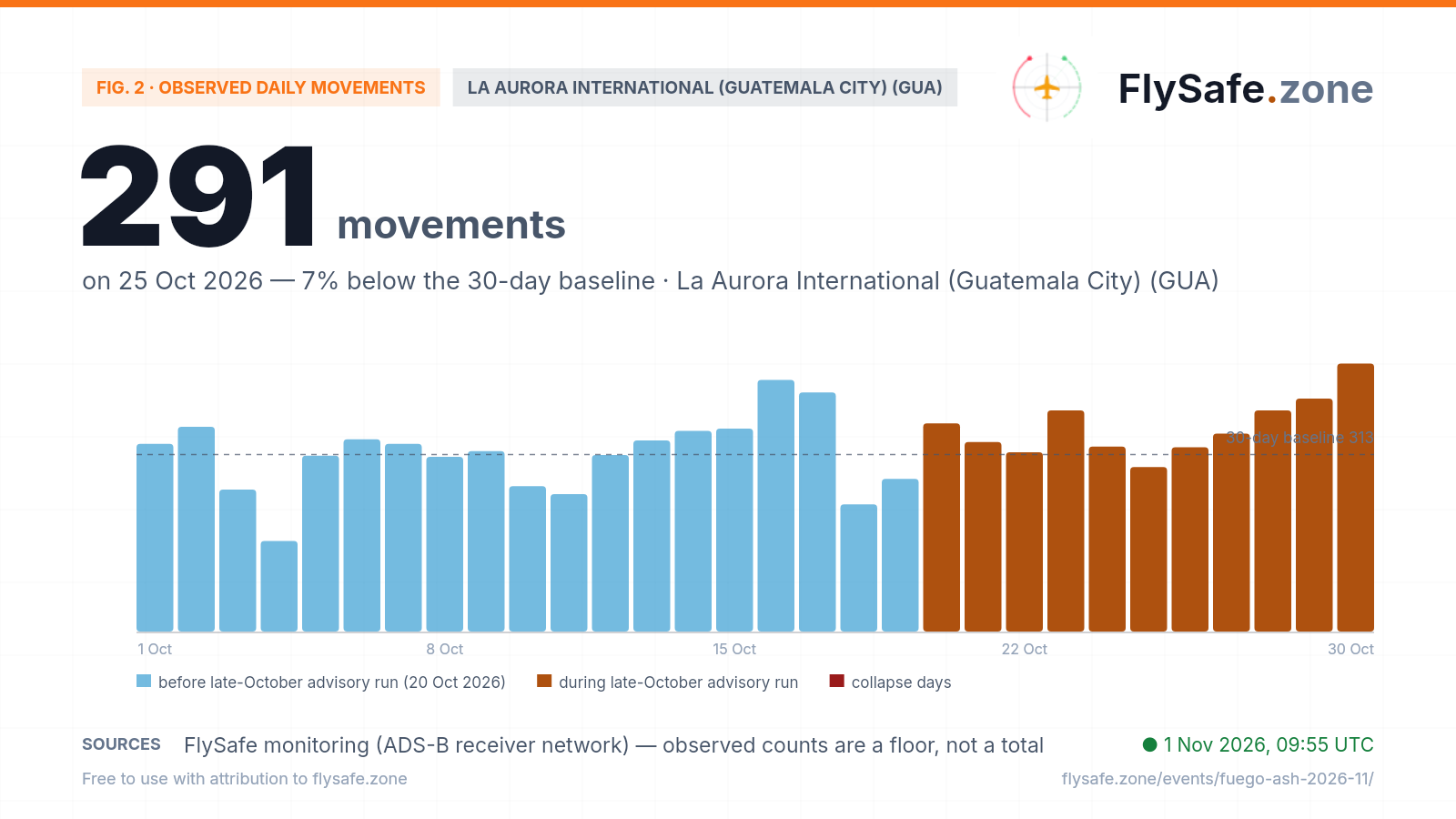
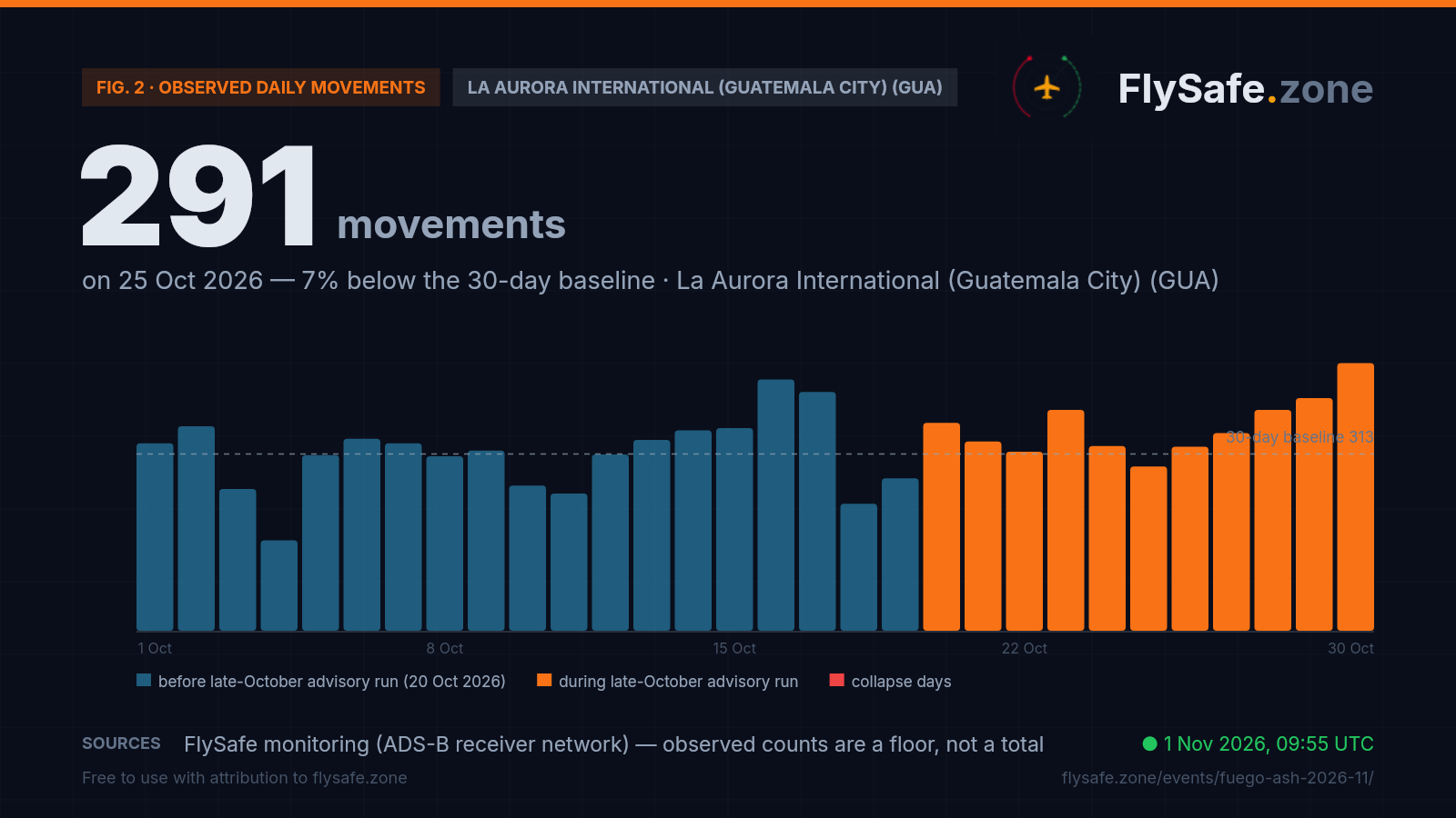
What our monitoring shows: La Aurora ran above its early-October level through the whole run — including the day the ash reached it
FlySafe tracks observed departures and arrivals at 493 airports from crowdsourced ADS-B receiver data. Observed counts are a floor, not a total — receiver coverage varies — but an airport measured against its own baseline is a reliable shape. La Aurora International (Guatemala City)'s last 30 days:
Fig. 2 — Observed daily movements at GUA, 1 Oct – 30 Oct (latest complete UTC day). Data as of 1 Nov 2026, 09:55 UTC · Source: FlySafe monitoring (ADS-B receiver network).
- Observed baseline at Guatemala City (GUA), 1–19 October: ~313 movements/day — 83% of August's ~377. Fuego emitted on every one of those days, so this is an earlier-October baseline, not an ash-free one; the slide from August is examined on the GUA traffic brief.
- Since the run began: 344/day across the nine settled days, 20–28 October — 10% above the 1–19 October mean and 91% of August. The daily readings: 368, 335, 317, 391, 327, 291, 326, 350, 391. Thursday 29 October reads 412 and Friday 30 October 474 — the busiest day in this window and the highest since 15 September — both provisional; our GUA airport brief classifies 30 October a normal day, 21% above its own Friday baseline of 391.
- The ash day. Wednesday 28 October, when the 10:10 UTC observed ash area covered the airport, has settled at 391 movements (204 departures, 187 arrivals) — the busiest Wednesday of October, against 332, 355 and 335. Between 10:10 and 16:00 UTC the network logged 140 movements at La Aurora (94 departures, 46 arrivals), against 131 in the same hours a week earlier and 148 two weeks earlier. We report the counts beside the geometry and attribute nothing either way.
- Weekday by weekday, nothing fell back. None of the nine settled days fell below the range of the earlier October days for the same weekday, and four set the October high for theirs: Tuesday 20 (368, against 340 and 338), Sunday 25 (291, against 160, 243 and 225), Monday 26 (326, against 311, 312 and 270) and Wednesday 28 (391). Sunday 25 October is the run's lowest day and the key day on Fig. 2 — 7% under the 1–19 October mean, and still the busiest Sunday of the month.
- Bookkeeping on the last days. 29 October is plotted at 412, our recount from the raw flight records: the daily aggregate stores 375 because a refresh at 09:25 UTC today cut that day short; it settles on 2 November. 30 October (474) is provisional and settles on 3 November. 31 October is not plotted: the receiver network's worldwide count for that day stands at about a tenth of a normal day while data backfills, so the 45 movements it holds for GUA say nothing about the airport yet.
- The smaller fields. San José (GSJ), the Pacific-coast airfield the southward drift crossed on 27–28 October, is too small for a daily reading: the network logged 281 movements there across October, about nine a day — a floor that cannot say whether any flight was moved or cancelled. This page makes no traffic statement for Retalhuleu (RER) or Tapachula (TAP).
- Honesty note — this is not an attribution. These are observed movements from a crowdsourced ADS-B receiver network: a floor, not the airport's official total, and recent days revise as data backfills. A movement count at GUA is a statement about the airport, never about which volcano caused what — Santa María, 112 km west, is under its own advisories.
Live view: GUA airport brief.
What it means for flights
A November page for an advisory run that did not stop. The October page closed on VAAC Washington's no-ash bulletin of 00:30 UTC on 10 October. Fuego did not wait: at 07:06 UTC that morning, 6.6 hours later, a new advisory reported an ash cloud drifting south-west from the summit on satellite, and 34 ash-bearing advisories followed to 18 October — in line with the three earlier no-ash bulletins in our record (18 and 20 May, 13 June), each followed by fresh ash within 4½ to 8 hours. Then came the one real pause since 11 May: a no-ash bulletin at 13:10 UTC on 18 October, and 49 hours with no Fuego bulletin at all, until 13:57 UTC on 20 October. Since then the sequence has run four or five advisories a day, 50 in all, every one carrying ash. This page therefore opens on the first advisory of November, not on a new eruption: the 04:19 UTC bulletin describes the kind of emission Fuego has produced all year — ash puffs seen on satellite, surface to FL150, carried west on the prevailing flow. What makes the late-October run worth a page of its own is where the ash went for five days of it, and on one morning in particular.
28 October: the first observed ash area over La Aurora in our record. At 10:51 UTC on 28 October VAAC Washington reported frequent emissions moving east and south-east on satellite, with the winds at ash level quickly backing. Its observed area for 10:10 UTC — surface to FL140, moving east at 5 kt — reached about 52 km from the vent and took in La Aurora International (GUA), about 3 km inside its north-east edge; the 16:00 UTC forecast area in the same advisory contained the airport too, about 2 km inside. The Tegucigalpa watch office's SIGMET 2, valid 11:00–17:00 UTC, drew the same area for the Central American FIR, and its 16:00 UTC forecast area also contained the airport. Testing the published polygons directly, it is 1 of the 742 observed and 1 of the 2,089 forecast Fuego ash areas in our record since 11 May that contain La Aurora; before that morning the closest had been about 10 km observed and about 2 km forecast, both on 20 September. By the next observation, at 15:40 UTC, the ash had fanned south to south-east up to 50 NM from the summit and its nearest edge was about 27 km from the airport; every later observed and forecast area has stayed 35 km or more away. On the ground, La Aurora's hourly METARs from 09:00 to 18:00 UTC reported CAVOK or 10 km visibility and no volcanic ash — none of its 4,305 METARs since 13 May has reported ash — and the network logged 140 movements there between 10:10 and 16:00 UTC, against 131 a week earlier. A drawn ash area is VAAC Washington's envelope for where ash is in the layer from the surface to FL140, not a measurement at the runway; we report the geometry and the observations side by side, and the operating calls that day belonged to the airport and the airlines. The morning was first reported on the GUA traffic brief.
Five days of easterly drift — the heading that decides exposure here. Distance tells you little at Fuego; the drift vector in each advisory decides who is downwind. Guatemala City sits about 40 km from the vent on a bearing of roughly 073°, and in the record to 9 October 53 of 646 observed areas (8%) moved north-east, east, south-east or south. Since 20 October it has been 19 of 50 (38%), in four runs: 17:54 UTC on 23 October to 23:42 UTC on 24 October (six areas moving north-east, east or south-east, the nearest edge to La Aurora about 18 km on 24 October); 11:09 UTC on 25 October to 12:19 UTC on 26 October (six, south-east and south, reaching about 68 km from the vent); 23:59 UTC on 26 October to 17:08 UTC on 27 October (four, south, up to 50 NM); and the three of 28 October — the east-moving area over the airport and two that swung south-east and south. The southward legs crossed the Pacific-coast airfield of San José (GSJ), 60 km south of the vent: it sat inside the observed areas of 17:08 UTC on 27 October and 16:01 UTC on 28 October and inside four forecast areas since 10 October; 3 of the 742 observed areas on record contain it, the first on 30 September. Every advisory since 02:24 UTC on 29 October — 14 of them — has the ash moving south-west or west; the widest area, at 16:43 UTC on 31 October, reached about 118 km west-south-west of the vent. That swing brings Retalhuleu (RER), 88 km west, back into view: the 22:28 UTC advisory of 31 October put it inside its 10:00 and 16:00 UTC forecast areas for 1 November, though no observed area has contained it since 16 September (32 of 742 on record) and the 04:19 UTC forecasts stop about 25 km short. None of this is a forecast we make — it is the published geometry, and the wind at ash level can turn.
FL140–FL160 is a low band — it matters in the terminal area, not at cruise. Fuego's summit stands at 12,346 ft, and every advisory since 20 October has reported ash from the surface to between FL140 and FL160 — roughly 14,000 to 16,000 ft pressure altitude, a few thousand feet above the crater: FL140 on 34 advisories, FL150 on 10 and FL160 on six (26, 29, 30 and 31 October), the first FL160 since 28 September. The current advisory reports FL150. The 90-day range is FL130–FL180, and nothing above FL160 has been reported since 13 September. Traffic crossing Central America at cruise passes far above that band, which is how a volcano can generate 735 bulletins in our record without touching the long-haul network. La Aurora's field elevation is 4,952 ft, so its arrivals and departures work through part of the band on every rotation — which is why an east-moving plume matters to Guatemala City in a way a west-moving one does not. The share of areas seen directly on satellite has risen: 19 of the 50 since 20 October were estimated from webcam and model winds under weather cloud, but 12 of the 15 since the evening of 28 October were observed. That is why dispatchers read the reported level and the drift line in each advisory, not the distance from the summit alone.
One FIR, two bulletin streams — read FIR-level signals as FIR-level. The VAAC advisory says where ash is and where it is forecast to go; the SIGMET is what an en-route crew is told. The Tegucigalpa meteorological watch office (MHTG) issues the volcanic-ash SIGMETs for the Central American FIR (MHCC), and it has issued 48 for Fuego since 20 October (a re-issue for the same validity period counted once) — tops of 14,000 ft on 34, 15,000 ft on 8 and 16,000 ft on 6 — with a Fuego SIGMET issued on every day since 1 July except 19 October. Our SIGMET record begins 1 July, so that is a floor. The current one, SIGMET 1, runs 05:00–11:00 UTC on 1 November, surface to FL150, moving west at 15 kt. The same office covers Santa María, 112 km west of La Aurora, which is under its own advisories (Santa María brief). Across the whole FIR, aircraft counted crossing it ran between 0.97× and 1.05× their weekday baseline on every day from 20 to 31 October — 1.05× on 28 October — and the 24-hour reading behind our ash map stood at −8% at 09:25 UTC on 1 November: FIR-wide figures spanning several countries, which we do not attribute to either volcano. Our detection layer logged five low-confidence tracking entries for this airspace after the October page closed (13, 13–14, 18, 21 and 22–23 October), each already past its end time; none since 23 October and none open. The FIR's NOTAM set, refreshed at 05:02 UTC on 1 November, carries no ash notice and no airport closure; its one airspace restriction is a route closure in Guatemalan airspace (ATS route R644, AUR–TIDER, surface to FL170) in force since 2 September, whose text gives no cause. The set holds current notices, so it cannot show one that has already lapsed.
What we watch for escalation. Three signals would change this page. Cadence: the run has held four or five advisories a day since 21 October; a sustained ten-plus a day would mark a different volcano — the busiest day in our record is six (4 July, 4 August, 10 and 14 September). Height: reported tops above FL180, the highest in our record (4 and 14 August). Reach: another observed area over La Aurora — it has happened once, on 28 October, when the drift backed east — or an observed area over Retalhuleu while the drift holds west. The 04:19 UTC advisory expects little change in the winds at ash level over the next 18 hours, which would keep the plume moving west. Automated multi-signal analysis checks all three every three hours, alongside observed airport movements and FIR-level traffic, and this page, the GUA brief and the live ash map update from the same cycle. The operating decision on any given day stays where it belongs — with the airport, the airline and the Guatemalan and Central American authorities.
Passenger questions, answered from the data
As of 09:55 UTC on 1 November 2026, VAAC Washington's latest advisory (04:19 UTC) reports Fuego's ash from the surface to FL150 moving west at 15 kt — away from Guatemala City — and the current volcanic-ash SIGMET for the Central American FIR runs to 11:00 UTC. La Aurora (GUA), 40 km east-north-east of the vent, has been inside one observed ash area in our record since 11 May — at 10:10 UTC on 28 October, when the drift briefly turned east — and every observed area since has stayed 35 km or more away. None of the airport's METARs since 13 May has reported volcanic ash, and observed traffic ran above its early-October level through the run. Check your airline's status on the day of travel and the live ash map.
Once in our record. VAAC Washington's 10:51 UTC advisory on 28 October placed satellite-observed ash at 10:10 UTC from the surface to FL140, moving east at 5 kt, over an area that took in La Aurora about 3 km inside its edge; the Tegucigalpa watch office's SIGMET 2 covered the same area from 11:00 to 17:00 UTC. By the next observation, at 15:40 UTC, the ash had fanned south and south-east and its edge was about 27 km from the airport. It is 1 of 742 observed Fuego ash areas since 11 May to contain the airport. The airport's METARs that day reported CAVOK or 10 km visibility and no volcanic ash, and the network logged 391 movements there, the busiest Wednesday of October. Whether a flight operates is a decision for the operator and the Guatemalan authorities.
Because our pages follow the advisory record month by month, and the October page closed on 10 October with VAAC Washington's no-ash bulletin. Advisories resumed 6.6 hours later, ran to 18 October, stopped for 49 hours — the longest silence in our record since 11 May — and have come every day since 20 October, 50 to 04:19 UTC on 1 November. That late-October run, including the ash over La Aurora on 28 October, is summarised here; the early-October record stays on its own page. Fuego is a persistent emitter, not a volcano in a single new eruption: our record since 11 May holds 735 bulletins on 174 of 175 days.
Observed movements at La Aurora averaged 344 a day across the settled days 20–28 October, 10% above the 1–19 October mean and about 91% of August. None of those days fell below the range of earlier October days for the same weekday, and Friday 30 October (474, provisional) was the busiest day since mid-September; our GUA airport brief classifies it a normal day. Counts come from a crowdsourced ADS-B network and are a floor, not official totals, and our data does not tie the traffic to the volcano. Details: GUA airport brief.
Aircraft do not fly through reported ash — dispatchers file around the advisory and SIGMET areas, and regulators close airspace if ash reaches it. We publish the measured picture: advisory cadence, reported flight levels, drift directions, the geometry of each observed and forecast ash area against each airport, observed airport movements and FIR-level en-route counts. Routing and go/no-go decisions belong to operators and the relevant authorities, not to us. Guatemala also has more than one active volcano — Santa María lies about 112 km west of La Aurora and issues its own advisories.
For media — the full kit
Everything on this page — charts, CSV, quotes — is published under CC BY 4.0: free to reuse with attribution to FlySafe.zone. Charts come in dark (social/web) and light (print/light layouts) versions; attribution and license are embedded in every file.
“Fuego volcano in Guatemala has produced ash advisories every day since 20 October 2026 — 50 to 04:19 UTC on 1 November, when VAAC Washington reported ash from the surface to FL150 moving west at 15 kt — and on 28 October a satellite-observed ash area moving east at 5 kt covered Guatemala City's La Aurora airport for the first time in the record since 11 May, 1 of 742 observed areas, while the airport's weather reports carried no volcanic ash and its observed traffic that day, 391 movements, was the busiest Wednesday of October, according to flight-monitoring service FlySafe.zone.”
Boilerplate — about the source (for your article footer)
FlySafe.zone monitors airspace risk and observed airport activity worldwide: 334 flight-information regions scored daily, GPS-interference signals, volcanic-ash exposure and daily observed movements at 493 airports from the crowdsourced ADS-B receiver network. Methodology: flysafe.zone/methodology.
Need a different cut of the data, a comment, or numbers for another airport? Leave an email — we answer fast during active events.