GNSS Interference North of Warsaw, November 2026: 48 of 63 Aircraft (76%) Flag Degraded Navigation over Masuria on 13 November — a Cell That Has Read 61–97% Every Day Since August, Not a New Zone
- Warsaw Chopin (WAW) and Warsaw Modlin (WMI) read normal traffic on their airport pages — GNSS interference degrades navigation avionics, it does not stop flights. Chopin's lower November counts follow the winter timetable, which cut traffic across the region.
- The high reading is north of the city, over Masuria, in a cell that has read high on every observed day since August; the share flagged falls from near 100% at the Kaliningrad border to about a third over Warsaw itself.
- The Warsaw FIR has carried a NOTAM since September warning crews to expect GNSS jamming and spoofing and noting conventional navigation aids are available — what we measure is navigation integrity, not a verdict: go/no-go decisions belong to operators and authorities.
Advisory timeline — how active is this episode
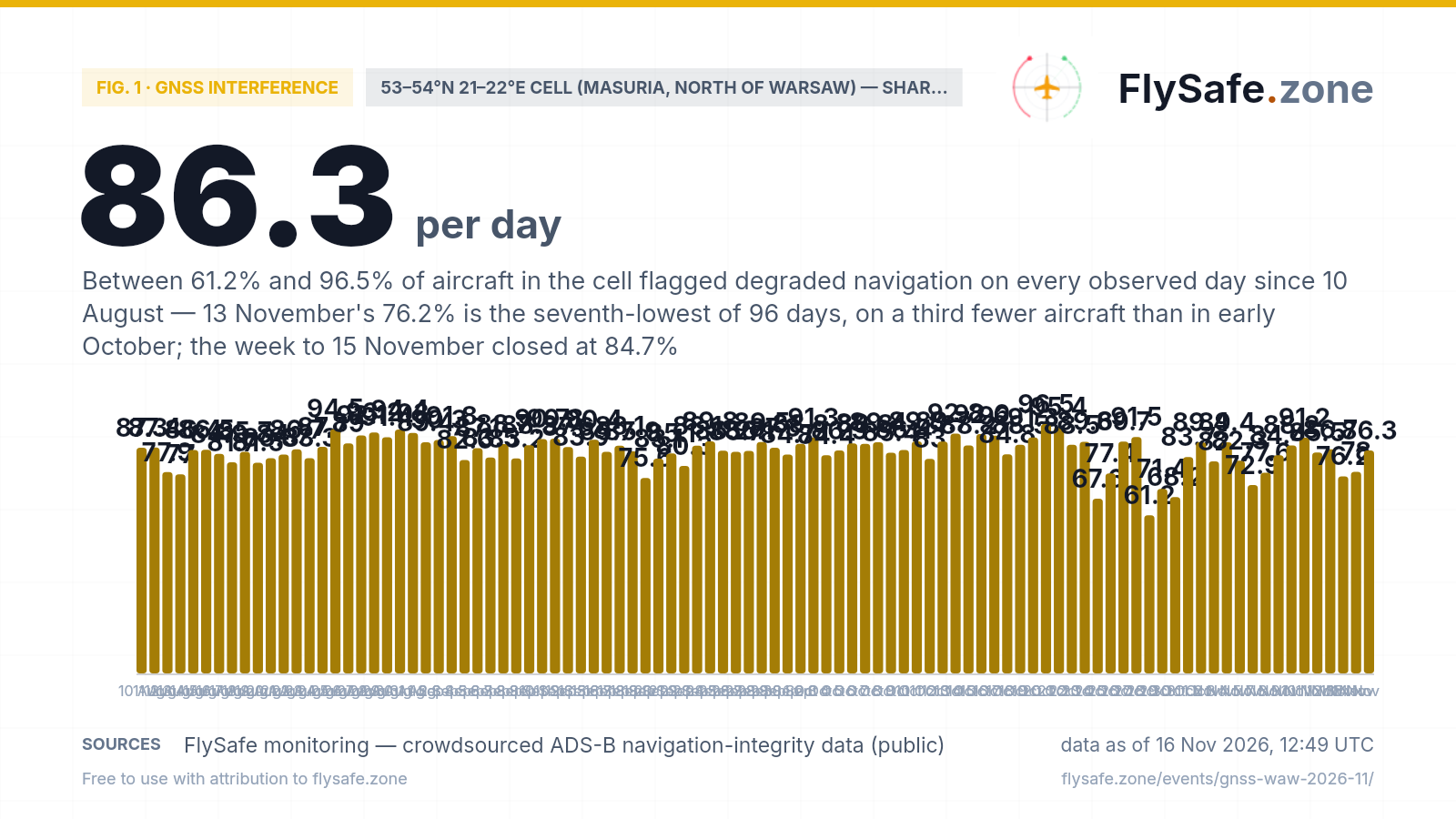
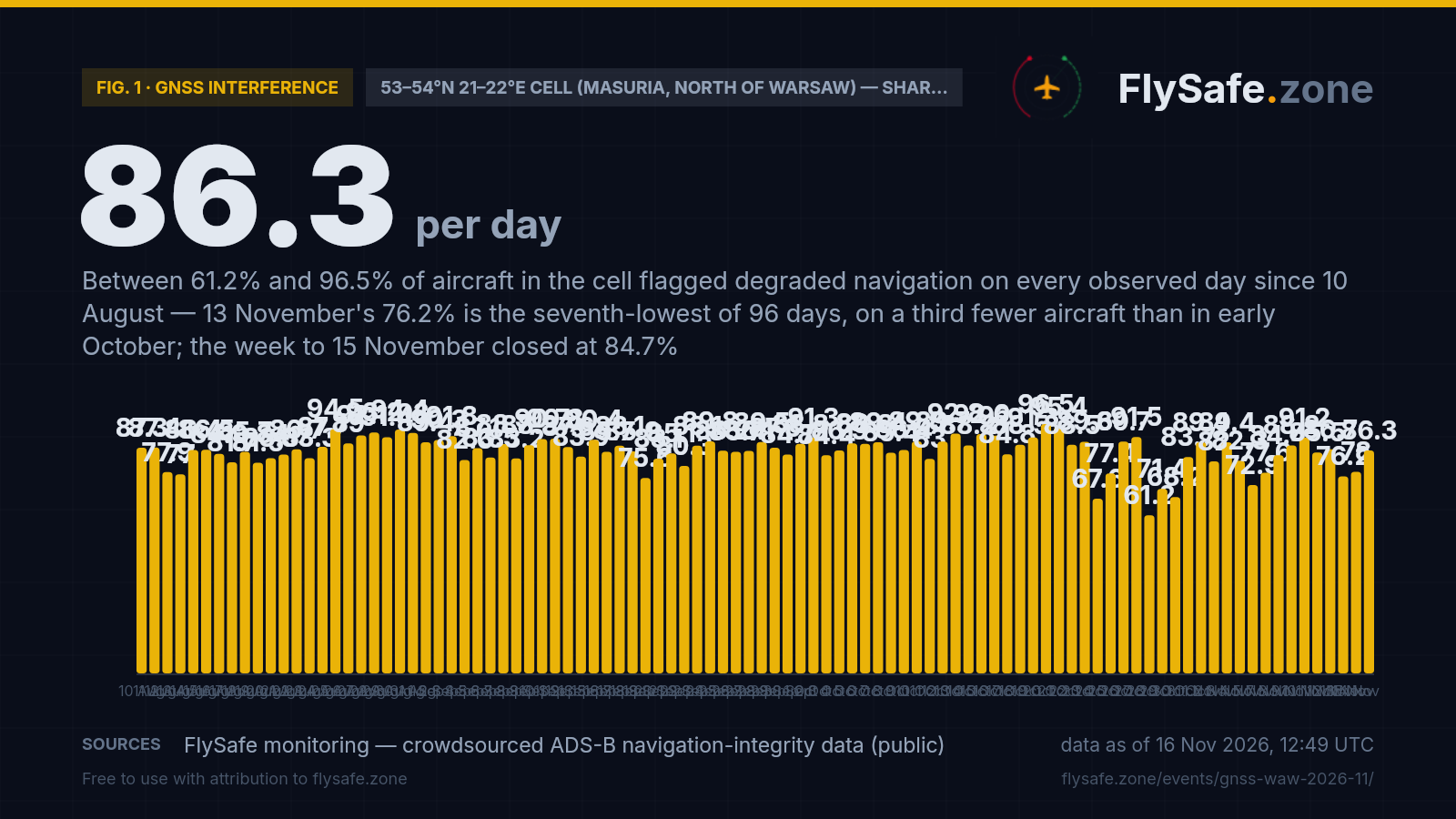
This is not an eruption or a storm. It is a reading from one 1°×1° grid cell — 53–54°N 21–22°E, the Masurian lake district and the Kurpie forest down to Ostrołęka, entirely inside the Warsaw FIR (EPWW), its northern edge about 40 km short of the Kaliningrad border — where aircraft broadcasting ADS-B report a low navigation-integrity category, the broad flag that their GNSS position confidence has dropped. On 13 November 48 of 63 tracked aircraft (76.2%) carried that flag, which is what our detection layer picked up. The honest context is the history: the cell has read 61.2–96.5% on all 94 observed days since 10 August — 87.0% for 10–31 August, 86.7% for September, 86.4% for October, 83.9% for 1–13 November — and 13 November is its seventh-lowest day, not a high. The detection called it a new zone because its comparison day, 6 November, is missing from the crowdsourced feed at every cell, so there was no week-earlier reading to compare against. What has changed since late October is the sample: the cell averaged 94 aircraft a day on 13–24 October and 66 on 25 October–13 November, and the share over those later days is 81.7% against 87.2% before. Eight of the cell's eleven days under 80% fall after 23 October. We report that, we do not call it a trend. 14 September and 6 November are omitted (feed-wide gaps). Close-out, 16 November: the two days since read 78.0% (46 of 59) on 14 November and 86.3% (63 of 73) on 15 November, and the calendar week 9–15 November closed at 84.7% (383 of 452); across 96 observed days, nine of the cell's twelve days under 80% now fall after 23 October. Share flagged, every observed day:
Fig. 1 — daily share of tracked aircraft broadcasting a low Navigation Integrity Category (NIC) in the 53–54°N 21–22°E cell (Masuria, north of Warsaw), %, 10 Aug–15 Nov 2026, 96 observed days with 49–132 aircraft each — crowdsourced ADS-B network; 14 Sep and 6 Nov are feed-wide collection gaps and are omitted, not plotted as zero · Data as of 16 Nov 2026, 12:49 UTC · Source: FlySafe monitoring — crowdsourced ADS-B navigation-integrity data (public).
Airports in the exposure zone
| Airport | Size | Distance from cell centre | FIR |
|---|---|---|---|
| Olsztyn-Mazury Airport (SZY) | small | 37 km · adjacent cell 53–54°N 20–21°E 79.6% flagged on 13 Nov (39 of 49; 80.9% over 7 days) · 1–11 observed movements/day, too few to chart | EPWW |
| Warsaw Modlin Airport (WMI) | medium | 130 km · shares Warsaw's cell 52–53°N 20–21°E, 35.1% on 13 Nov · 70 observed movements on 13 Nov · airport page rates traffic normal | EPWW |
| Warsaw Chopin Airport (WAW) | large | 153 km · own cell 52–53°N 20–21°E 35.1% flagged on 13 Nov (91 of 259; 32.0% over 7 days) · 481 movements on 13 Nov, level with its winter-timetable average | EPWW |
| Khrabrovo Airport (Kaliningrad) (KGD) | medium | 165 km · own cell 54–55°N 20–21°E 93.3% flagged on 13 Nov (42 of 45; 97.6% over 7 days) · Kaliningrad FIR 27.3% FIR-level over 7 days, thin sample · no observed-movement count published | UMKK |
| Brest International Airport (BQT) | small | 223 km · own cell 52–53°N 23–24°E 83.9% flagged on 13 Nov (47 of 56; 86.1% over 7 days) · Minsk FIR 24.3% FIR-level over 7 days · no observed-movement count published | UMMV |
Distance alone does not determine impact — wind direction and the flight levels the ash reaches decide which airports and routes are affected on a given day. FIR = Flight Information Region.
What our monitoring shows: Warsaw Chopin traffic around the reading
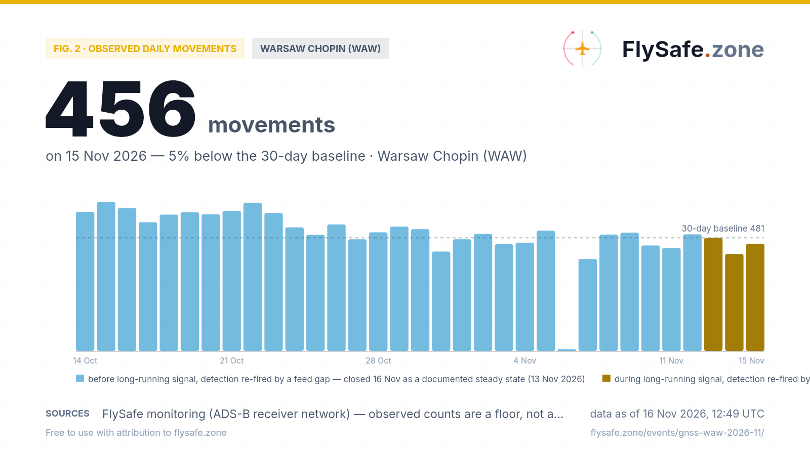
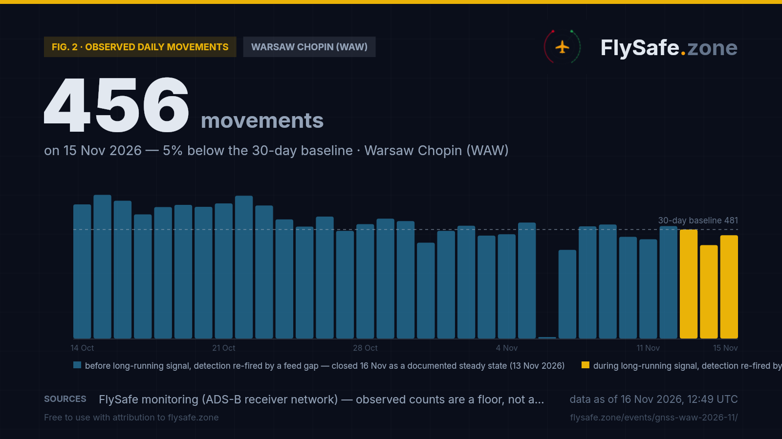
FlySafe tracks observed departures and arrivals at 493 airports from crowdsourced ADS-B receiver data. Observed counts are a floor, not a total — receiver coverage varies — but an airport measured against its own baseline is a reliable shape. Warsaw Chopin's last 30 days:
Fig. 2 — Observed daily movements at WAW, 14 Oct – 15 Nov (latest complete UTC day). Data as of 16 Nov 2026, 12:49 UTC · Source: FlySafe monitoring (ADS-B receiver network).
- The chart has a step in it, and the step is the timetable, not the interference. Across 14–24 October Warsaw Chopin averaged ~588 observed movements a day on the crowdsourced network plotted here (range 526–634). From Sunday 25 October — the first day of the northern winter timetable — it averaged ~481 (18 days with data to 12 November, range 391–538), about 18% lower. The reference line on the chart is that winter-level average. Observed counts are a floor, not a total.
- The step is regional. On the same network and the same dates (13–24 October against 25 October–12 November), Kraków fell 12%, Gdańsk 23%, Katowice 29%, Riga 17%, Frankfurt 16% and Amsterdam 10%. Warsaw sits inside that spread; we do not attribute any of it to GNSS interference.
- Friday 13 November, the day of the cell reading — 481 movements (236 departures, 245 arrivals), level with the winter-level average and 7% under the one earlier winter-timetable Friday, 30 October (518). The softest day of the window is Saturday 7 November (391); the other winter Saturday, 31 October, read 423. The seven days to 13 November averaged 465.
- Close-out, 16 November — Saturday 14 November 412 movements (203 departures, 209 arrivals), Sunday 15 November 456 (234/222). The winter-timetable average is now about 476 (25 October–15 November, 21 days with data). 14 November sits between the other two winter Saturdays (391 and 423); 15 November is the lowest of the four winter Sundays (the others 475–495), 5% under the reference line. We report both, we do not attribute them.
- Gap day: 6 November is missing from this network at every airport — drawn as a blank stub, not a zero.
- Why this feed: the WAW airport page runs on our primary receiver feed, which differs from this one by a few dozen movements on some days and rates 9 November normal (483 movements, −9% against its Monday reference of 532). As of 16 November that feed still has not collected 10–15 November, so the network plotted here, which closes each day the next morning, is the one that can show the days after 9 November.
For GNSS interference a traffic gauge is a secondary instrument: jamming and spoofing degrade what avionics compute, not how many aircraft move. It is here to show that a 76% low-integrity reading over Masuria and an ordinary winter Friday at Chopin coexist. Live view: WAW airport brief.
What it means for flights
GNSS interference is a navigation problem, not a runway problem. Ash is an engine problem and wind is a runway problem; jamming and spoofing are a position problem — they corrupt the GNSS fix an aircraft computes. Airliners carry independent navigation sources (inertial reference, DME/DME, VOR) and fly published procedures under ATC surveillance, so degraded GNSS is absorbed rather than grounding traffic. That is why a cell over Masuria can show three in four aircraft flagging low integrity while Warsaw Chopin runs a 481-movement day. The cost is crew workload and reduced margin, not cancelled flights.
Read the 76.2% for what it is: a low day in a cell that is always high. The 53–54°N 21–22°E cell is busy enough to measure — 49 to 132 aircraft on every observed day — and it has never read below 61.2% (28 October, 30 of 49). Across all 94 observed days since 10 August it has seen 8,729 aircraft, 7,543 of them flagged (86.4%); its highest day is 20 October (96.5%, 83 of 86). On 13 November it read 76.2% (48 of 63), the seventh-lowest day of the series, and its seven-day share is 84.5% (377 of 446). The detection threshold — at least 60% of at least 30 aircraft — has been met on every one of the 94 days. It fired now because the week-earlier comparison day, 6 November, is missing from the feed at every cell: the absence of data read as the absence of a signal. An earlier FlySafe brief covered the same pattern east of Warsaw, where the 52–53°N 22–23°E cell read 93% through September and October; it closed as a documented steady state on 13 October (gnss-waw-2026-09), and that cell reads 93.0% for 1–13 November.
The gradient: near-total at the Kaliningrad border, about a third over Warsaw. The low-integrity flag is broad; how high it reads depends on where the cell is. Seven-day shares to 13 November, north to south: the cells along the Kaliningrad and Lithuanian border read 93.0–99.6% (54–55°N 20–24°E), the row containing this cell 80.9% (53–54°N 20–21°E, Olsztyn), 84.5% (this cell), 98.4% (22–23°E, towards Ełk) and 97.2% further east, and the Warsaw row drops to 32.0% over Chopin and Modlin (52–53°N 20–21°E) and 34.8% just east of it, before rising again to 93.1% and 86.1% towards the Belarusian border. Warsaw's own cell read 34.5% for 10–31 August, 38.3% for September, 39.6% for October and 33.8% for 1–13 November. These are cell-level aggregates of aircraft telemetry, not per-flight figures.
The FIR-level picture: the Warsaw FIR low and flat, its eastern neighbours high and flat. The stricter jamming-grade ratio is a FIR-level aggregate, labelled as such. Over the Warsaw FIR (EPWW) it read 3.33% on 13 November (of about 14,200 tracked aircraft), with a seven-day mean of 3.3%, a 90-day mean of 3.8% and a 14-day range of 3.0–4.9%. Its monthly means barely move: 3.7% in July, 3.3% in August, 3.9% in September, 4.0% in October (25 October is missing from the FIR feed) and 3.5% for 1–13 November. The Kaliningrad FIR (UMKK) read 29.1% on about 86 tracked aircraft — a sample small enough that the feed rates its confidence low — with a seven-day mean of 27.3% against a 90-day mean of 29.0%. The Vilnius FIR (EYVL) reads 18.6% over seven days (90-day 19.8%), the Minsk FIR (UMMV) 24.3% (90-day 23.1%).
What the published notices say. The current Warsaw FIR NOTAM set (34 notices, collected through 14 November 09:33 UTC) carries one GNSS notice: C0848/26, replacing C0576/26, which states that GNSS jamming and spoofing occurrences can be expected within FIR EPWW, asks crews to remain vigilant and report to ATS, and notes that conventional navigation aids are available. It is FIR-wide, valid from 11 September with an estimated end of 11 December 2026. The set carries no notice for Warsaw Chopin or Modlin that cites navigation interference. Our notice set holds no current notices for the Kaliningrad or Vilnius FIRs — we read that as a gap in our coverage, not as an absence of notices; operators work from their own briefing packages.
What would change this story. Another high day in this cell would not, on its own: it has read high on every observed day for three months. The tests we are watching instead: Warsaw's own cell above 50% for a calendar week (its highest month is 39.6%, October); the Warsaw-FIR seven-day jamming-grade mean above 4.9%, the top of its 14-day range; a sustained fall in this cell's share below its 61.2% floor, which would be the first sign of easing; a NOTAM series suspending GNSS-based procedures at Chopin or Modlin; or diversions and go-arounds attributable to lost navigation. Separately, we will report whether the cell's softer readings since 24 October, on fewer aircraft, hold or reverse. Our automated multi-signal analysis checks the navigation-integrity streams against notice and traffic signals every three hours, and this page and the WAW brief update from the same cycle. If none of the tests fires, the brief closes as a documented steady state.
What the data showed — close-out, 16 November. We are closing this brief as a documented steady state, not because the interference has stopped. The detection fired on 13 November because its comparison day was missing from the feed; the two observed days since read 78.0% (46 of 59) on 14 November and 86.3% (63 of 73) on 15 November, and the calendar week 9–15 November closed at 84.7% (383 of 452 aircraft) — inside the cell's range, and above the two weeks before it (79.9% for 26 October–1 November; 81.6% for 2–8 November, six observed days because 6 November is a feed-wide gap). Across all 96 observed days since 10 August the cell reads 86.4% (7,652 of 8,861); 25 October–15 November reads 81.8% on about 66 aircraft a day, so the softer, thinner-sample stretch has eased back towards the band rather than reversed. None of the tests this page set fired: Warsaw's own cell read 32.6% and 38.3% on 14–15 November and 32.5% for 9–15 November (34.0% for 1–15 November), far from the 50% mark; the Warsaw-FIR seven-day jamming-grade mean is 3.3% for 9–15 November (90-day 3.8%), well under 4.9% — 14 November's 2.94% is its lowest day since 19 August; this cell never fell below its 61.2% floor; and the Warsaw FIR notice set, refreshed 16 November 12:33 UTC, still carries C0848/26 as its single GNSS notice and no notice suspending GNSS-based procedures at Chopin or Modlin. Diversions and go-arounds attributable to lost navigation are not something our data can show, so we make no claim either way. FIR-level seven-day means for 9–15 November sit near the levels reported on 14 November: Kaliningrad (UMKK) 27.7% on a thin sample, Vilnius (EYVL) 18.5%, Minsk (UMMV) 24.0%. Warsaw Chopin handled 412 and 456 observed movements on 14 and 15 November against a winter-timetable average of about 476. The navigation-integrity picture over north-east Poland is unchanged in our data; the WAW brief keeps tracking it, and a fresh brief opens only if one of the tests above fires.
Passenger questions, answered from the data
Airliners navigate with several independent systems, not GNSS alone, and Warsaw's airports were operating normally as of 14 November 2026 — Chopin (WAW) handled 481 observed movements on 13 November, level with its average since the winter timetable began on 25 October, and the Modlin airport page rates traffic normal. The Warsaw FIR NOTAM on GNSS jamming notes that conventional navigation aids are available. We publish the measured picture — navigation-integrity shares and throughput; routing and go/no-go decisions belong to operators and authorities. Check your airline's status on the day of travel.
Aircraft broadcast a Navigation Integrity Category with their ADS-B position — a statement of how much the avionics trust their own GNSS fix. A low value is a broad flag that the fix is degraded, which is what jamming (drowning out satellite signals) or spoofing (broadcasting false ones) produces. Crews cross-check against inertial and ground-based navigation and follow ATC, so passengers do not normally notice it; it raises workload rather than causing cancellations, and traffic over north-east Poland has continued through months of it.
Not on the measures we track. The 76.2% reading on 13 November comes from a cell over Masuria, north of Warsaw, that has read between 61.2% and 96.5% on every observed day since 10 August; 13 November is among its lower days. Warsaw's own cell read 35.1% that day and 33.8% for 1–13 November, against 39.6% for October, and the stricter FIR-level jamming-grade ratio over the Warsaw FIR has a seven-day mean of 3.3% against a 90-day mean of 3.8%. These are cell- and FIR-level aggregates from aircraft telemetry, reported as a floor from the crowdsourced receiver network.
For media — the full kit
Everything on this page — charts, CSV, quotes — is published under CC BY 4.0: free to reuse with attribution to FlySafe.zone. Charts come in dark (social/web) and light (print/light layouts) versions; attribution and license are embedded in every file.
“In the grid cell over Masuria, north of Warsaw, 48 of 63 tracked aircraft broadcast degraded GNSS navigation integrity on 13 November — one of the cell's lower readings in a run that has stayed between 61% and 97% on every observed day since August — while Warsaw's own cell read 35.1%, the Warsaw FIR's jamming-grade ratio stood at 3.3% and Warsaw Chopin handled 481 movements, level with its winter-timetable average, according to flight-monitoring service FlySafe.zone.”
Boilerplate — about the source (for your article footer)
FlySafe.zone monitors airspace risk and observed airport activity worldwide: 334 flight-information regions scored daily, GPS-interference signals, volcanic-ash exposure and daily observed movements at 493 airports from the crowdsourced ADS-B receiver network. Methodology: flysafe.zone/methodology.
Need a different cut of the data, a comment, or numbers for another airport? Leave an email — we answer fast during active events.