Popocatepetl Ash — New Emission Drifts Toward Mexico City: Ash to FL200, Observed Area Ends ~7 km Short of MEX, November 2026
- Ash is airborne again, and this time it is drifting toward Mexico City: advisory #378 (14:21 UTC, 4 November) puts ash from the ground to FL200 about 30 NM west-north-west of the summit, its observed area ending about 7 km short of MEX — the closest an observed area has come to the airport in our record since 12 May.
- MEX is outside every area drawn so far — the observed area and the three forecast areas for 20:00 UTC today and 02:00 and 08:00 UTC tomorrow (nearest forecast edge about 14 km). In our record MEX has never been inside an observed Popocatepetl ash area, and it fell inside forecast areas issued on three days (23 July, 3 August, 25 August). Check your airline on the day — wind moves ash, and each advisory redraws the areas.
- FL200 is the level that matters for arrivals and departures, not for high cruise: it is Popocatepetl's most common reported top (78 of the 155 bulletins that carried one since 12 May), below long-haul cruise levels over central Mexico and inside the band used by traffic climbing out of and descending into the capital.
- The October brief closed on 15 October, but the volcano did not stop: 21 more bulletins followed on six days, including a 19-bulletin run on 26–30 October that carried ash to FL210 and north-east toward Puebla, its observed edge about 2–3 km from that airport on 26 and 28 October. Today's emission ended a 115-hour silence.
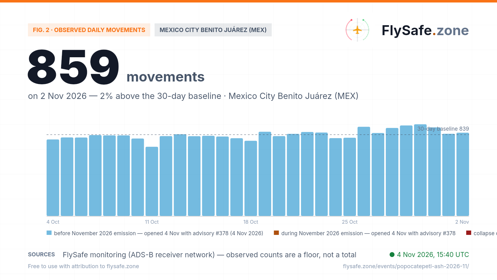
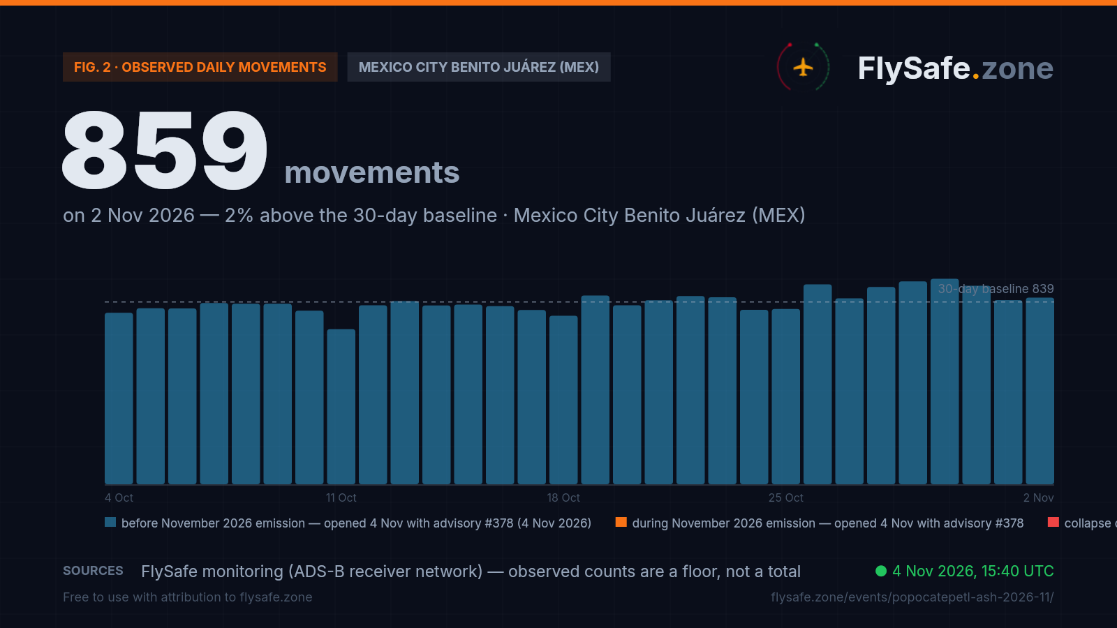
- Observed MEX traffic read 859 movements on Monday 2 November against an ~839 baseline (provisional; our MEX brief rates it a normal day), after six days at 856–946 on 26–31 October. 4 November has no usable reading yet — the bulk of a day's records lands two nights later.
Advisory timeline — how active is this episode
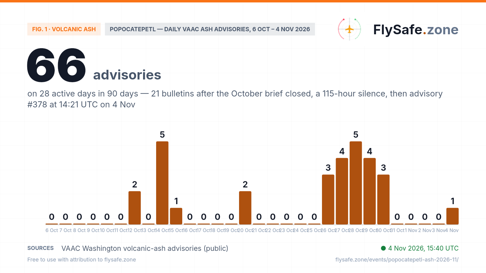
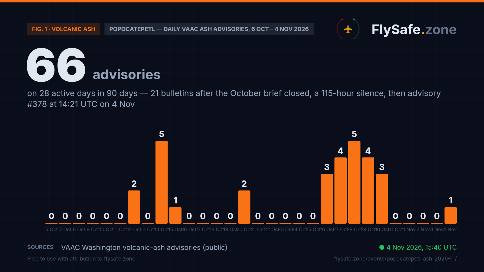
Popocatepetl is an episodic emitter: VAAC Washington has issued 66 ash advisories on 28 active days over the last 90 (since 6 August), and 203 bulletins on 71 days since 12 May, when our advisory collection begins — so every count here is a floor on the volcano's history, not its start. Our October brief closed on the no-ash bulletin of 02:53 UTC on 15 October (the 12–15 October bars below are that episode). The volcano did not stay quiet: 21 more bulletins followed on six days (advisories #358–#377, one of them issued twice): a pair on 20 October (#358 at 12:52 UTC, ash to FL190 moving west at 20 kt about 20 NM from the summit, dissipated by 18:43 UTC), then a 19-bulletin run from 14:16 UTC on 26 October to 19:22 UTC on 30 October, with tops rising from FL170–FL190 to FL210 on 28 October and the ash carried north-east and north — toward Puebla, away from the capital — out to about 80 NM north-east of the summit at 18:18 UTC on 28 October. The 19:22 UTC bulletin on 30 October (#377) reported no ash detected and no reports of emission. Then 115 hours of silence — after 130 hours (15–20 October) and 140 hours (20–26 October) in the two gaps before it — and at 14:21 UTC on 4 November, advisory #378: ongoing ash emission seen on the webcam and detected in satellite imagery at 14:06 UTC, ash from the ground to FL200, extending about 30 NM west-north-west of the summit, with model guidance for a general west-north-west motion through the next 18 hours. The zeros of 31 October – 3 November are the volcano's own quiet days, not a hole in the feed: VAAC centres issued 38–48 bulletins across 11–13 volcanoes on each of those days. The bars count every bulletin, including the four no-ash bulletins since 15 October and the reissue of #360 on 26 October; 4 November is a partial day. Daily advisory count, 6 October – 4 November:
Fig. 1 — Popocatepetl daily ash advisory count, VAAC Washington (Oct–Nov 2026) · * partial day · Data as of 4 Nov 2026, 15:40 UTC · Source: VAAC Washington volcanic-ash advisories (public).
Airports in the exposure zone
| Airport | Size | Distance from vent | FIR |
|---|---|---|---|
| Puebla Hermanos Serdán (PBC) | medium | 30 km · east-north-east of the vent, upwind of this emission — 30 km from the 14:06 UTC observed area and 27 km or more from every forecast area; the 26–30 Oct run passed about 2–3 km from it | MMFR |
| Mexico City Benito Juárez (MEX) | large | 66 km · north-west — outside the observed area, whose tip ends ~7 km short of the airport (14:06 UTC 4 Nov, FL200); nearest forecast edge ~14 km (20:00 UTC), 35–41 km on the 5 Nov forecasts | MMFR |
| Felipe Ángeles International (NLU) | large | 90 km · north-north-west, beyond MEX — 40 km from the observed area, 36 km or more from every forecast area | MMFR |
| Toluca Adolfo López Mateos (TLC) | medium | 105 km · west-north-west — 53 km from the observed area, 42 km or more from every forecast area | MMFR |
Distance alone does not determine impact — wind direction and the flight levels the ash reaches decide which airports and routes are affected on a given day. FIR = Flight Information Region.
What our monitoring shows: Mexico City's traffic was at baseline going into the emission — 859 observed movements on 2 November; 4 November is not yet measurable
FlySafe tracks observed departures and arrivals at 493 airports from crowdsourced ADS-B receiver data. Observed counts are a floor, not a total — receiver coverage varies — but an airport measured against its own baseline is a reliable shape. Mexico City Benito Juárez's last 30 days:
Fig. 2 — Observed daily movements at MEX, 4 Oct – 2 Nov (latest complete UTC day). Data as of 4 Nov 2026, 15:40 UTC · Source: FlySafe monitoring (ADS-B receiver network).
- Baseline: ~839 observed movements/day at MEX — the mean of the 28 settled days from 4 to 31 October (range 714–946; 776–946 leaving aside the 11 October Sunday at 714, the window's lowest day, which our October brief reported and did not attribute).
- Latest readable day: Monday 2 November, 859 (+2%) — provisional; the daily aggregate and our recount from the raw flight records agree. Mondays before it read 810, 824, 869 and 920. Our MEX airport brief rates 2 November a normal day, 1% under its Monday baseline of 869.
- 1 November is plotted from a recount. The daily aggregate stores 463 because the trailing-days refresh cut the day short, and our MEX brief flags it as a coverage gap; the raw flight records hold 848 (509 departures, 339 arrivals), which is the value plotted. The receiver network's pass for that day is short feed-wide — about 119,000 flights worldwide against 136,000–158,000 a day on 20–30 October — so 848 is a floor that can still rise; 1 and 2 November settle on 5 and 6 November.
- 3 and 4 November are not plotted. 3 November holds 181 movements, the first-night fraction of the feed (about 15,300 flights worldwide), not a reading; the emission was observed at 14:06 UTC on 4 November, and that day lands in the feed two nights from now. A second ADS-B aggregate reads 849 for MEX on 3 November, inside its own October range of 694–882.
- Late October ran high — and not near the ash. 26–31 October read 920, 856, 908, 934, 946 and 914 — the window's four highest days among them, mean 913 against 819 on 4–25 October (+12%); the second aggregate shows the same step (846 against 775, +9%). On 26–30 October Popocatepetl's ash was being carried north-east, away from the capital, so the rise is not the volcano's, and its cause is not established in our data. Puebla (PBC), the airport that run came closest to, read 73 and 74 observed movements on 26–27 October against 91–98 on 20–23 October, then 96, 93 and 109 on 28–30 October — small counts we report and do not attribute.
- Honesty note — this is not an attribution. These are observed movements from a crowdsourced ADS-B receiver network: a floor, not the airport's official total, and recent days revise as data backfills. A movement count says whether the airport kept operating at its usual observed level; it says nothing about reroutes, holding or added track miles, which this feed cannot see.
FIR level: across the Mexico FIR (MMFR), observed en-route transit counts ran 1.10–1.26× their weekday baseline on every day from 24 October to 3 November (1.26× on 2 November, 1.22× on 3 November) — a FIR-wide band we report and do not attribute. Our detection layer has no open airspace-disruption entry for MMFR; its one entry since 1 October is a low-confidence tropical-cyclone entry for 23–29 October, now ended. No volcanic-ash SIGMET for Mexican airspace appears in our SIGMET record since 25 September (13 Popocatepetl SIGMETs since 14 July), while Mexican thunderstorm and tropical-cyclone SIGMETs kept arriving through 14:05 UTC today — our collection, not an official archive. The NOTAM set we hold for MMFR was last refreshed at 05:02 UTC on 1 November (30 notices, none for volcanic ash), so it predates this emission and says nothing about notices issued today. Live view: MEX airport brief · live ash map.
What it means for flights
FL200 sits inside the Mexico City arrival and departure band. Ash from the ground to FL200 (~20,000 ft) is below the cruise levels of most traffic crossing central Mexico (typically FL310–FL390) but inside the altitudes used by aircraft climbing out of and descending into the capital's airports, and by lower-level regional routes. An active VAAC advisory at this level is a planning input: dispatchers file around the published ash areas on flight plans through the Mexico FIR (MMFR). In Popocatepetl's recent episodes our MEX movement counts stayed in their normal range — 824 and 843 on 12–13 October, 856–946 a day on 26–31 October — which says the airport kept operating at its usual observed level, not that no flight was rerouted. Whether any flight is moved, held or cancelled is decided by operators and the authorities; this page reports the geometry and the counts.
Why the ash came close to MEX this time — the geometry of advisory #378. Popocatepetl sits at 19.02°N 98.62°W; MEX is at 19.44°N 99.07°W, 66 km to the north-west (bearing about 314°). The 14:06 UTC observed area is drawn as a wedge from the summit out to a north-western tip at 19.38°N 99.03°W — on almost exactly the airport's bearing, about 59 km from the vent and about 7 km south-east of the airport's reference point — and south-west to 18.92°N 99.17°W. Testing the published airport coordinates against the polygon puts MEX outside it. The 20:00 UTC forecast area (T+6) keeps a northern point at 19.43°N 98.90°W, about 18 km east of the airport, with its nearest edge about 14 km away; the 02:00 and 08:00 UTC forecasts for 5 November pull the area back to the south-west, 41 and 35 km from MEX. That is the forecast as drawn at 14:21 UTC: wind direction at FL200 is model-dependent, and the next advisory, due by 20:15 UTC, redraws all three areas.
What the October brief did not cover: 21 bulletins between 20 and 30 October. Our October brief closed at 02:53 UTC on 15 October, when VAAC Washington reported no ash and scheduled no further advisory. 130 hours later the volcano resumed: advisory #358 (12:52 UTC, 20 October) drew ash to FL190 moving west at 20 kt about 20 NM from the summit, dissipated by 18:43 UTC. After a further 140-hour silence, a 19-bulletin run opened at 14:16 UTC on 26 October (#360, first issued at FL170 and reissued 13 minutes later at FL190) and ran to 19:22 UTC on 30 October. Its ash went the other way from today's: north-east and north, toward Puebla — tops FL190 on 26–27 October, FL200–FL210 on 28 October, FL200 on 29–30 October; at 18:18 UTC on 28 October ash was observed up to 80 NM north-east of the summit. Puebla (PBC) came within about 2 km of the observed area on 26 October and about 3 km on 28 October, and one forecast area drawn at 04:53 UTC on 29 October for 16:30 UTC took in the airport; MEX stayed 43 km or more from every observed area of the run and 24 km or more from every forecast area. Two no-ash bulletins inside the run (01:15 UTC on 28 October, 04:38 UTC on 30 October) were followed by new ash advisories 5.7 and 8.8 hours later. The October brief said a fresh brief would open if advisories resumed with an ash area; none opened for the 20–30 October bulletins, and this page is the first to carry them.
Popocatepetl's rhythm: bursts, silences, and no-ash bulletins that have never been the last word. Since 12 May our record holds 48 Popocatepetl bulletins reporting no ash identifiable, and every one of them has been followed by a new advisory with an ash area — after a median of about 32 hours, 20 of them within a day, the longest after 395 hours (26 September – 12 October). Today's emission followed the 30 October no-ash bulletin by 115 hours. The volcano works in bursts: 203 bulletins on 71 of the 177 days since 12 May, with silences of up to 16 days between them. FL200 is its most common reported top (78 of the 155 bulletins that carried one); the record reaches FL270. Drift has been west, south-west or north-west on 100 of the 155 bulletins with a stated motion — north-west, the airport's bearing, on 19 — so ash on the capital's side of the volcano is common; ash over MEX's position is not: no observed area in our record has contained the airport.
Three signals we watch next. The picture changes if: (1) an observed or forecast area reaches the airport — MEX has never been inside an observed Popocatepetl ash area in our record, and today's tip ends about 7 km short; (2) the emission builds — tops above the FL240 reached on 14 October, or four to five bulletins a day as on 14 and 28 October; or (3) the operational signals move — a volcanic-ash SIGMET for Mexican airspace (none in our record since 25 September), or Mexico City's observed movements for 4–5 November falling clearly below their own weekday baseline once those days become readable, two nights after each. None of these has fired on advisory #378. Automated multi-signal analysis rechecks the advisory stream, the ash-area geometry against each airport and the MEX traffic count on each three-hour cycle and updates this page and the MEX airport brief.
Passenger questions, answered from the data
As of 15:40 UTC on 4 November 2026, VAAC Washington's latest advisory (#378, 14:21 UTC) shows ash from the ground to FL200 west-north-west of the summit, its observed area ending about 7 km short of Mexico City Benito Juárez (MEX). The airport is outside the observed area and all three forecast areas (nearest forecast edge about 14 km at 20:00 UTC), and Mexico City's 14:55 UTC weather report carries no volcanic ash. The next advisory is due by 20:15 UTC and redraws the areas, so check your airline's status on the day of travel and the live ash map.
Advisory #378 reports ash from the ground to FL200 (~20,000 ft / ~6,100 m), based on webcam, satellite imagery and model guidance, with the same top on all three forecast areas through 08:00 UTC on 5 November. FL200 is Popocatepetl's most common reported top in our record; it sits below typical long-haul cruise altitude and inside the band used by arrivals, departures and lower-level routes in the Mexico FIR (MMFR). The late-October run reached FL210 on 28 October; the record since 12 May reaches FL270.
In our record since 12 May, no observed Popocatepetl ash area has contained MEX. The closest observed edges are today's (about 7 km, 14:06 UTC on 4 November) and 3 August's (about 8 km). Forecast areas — where VAAC Washington expects ash 6 to 18 hours ahead — took in the airport in advisories issued on three days: 23 July, 3 August and 25 August. During the October episode the nearest edge was about 30 km (14 October), and during the 26–30 October run 43 km or more for observed areas and 24 km or more for forecast ones.
That decision belongs to your airline and the authorities, and depends on where each new advisory draws the ash. What our data shows: in Popocatepetl's recent episodes Mexico City's observed traffic stayed in its normal range — 824 and 843 movements on 12–13 October, 856–946 a day on 26–31 October, against a baseline of about 839 — and Monday 2 November read 859. Today's figure is not yet measurable. A movement count shows whether the airport kept operating at its usual level; it cannot show individual delays or reroutes, so check your booking directly with your airline.
Aircraft do not fly through reported ash — dispatchers route around advisory polygons, and regulators close airspace if ash reaches it. We publish the measured picture (advisory cadence, reported flight levels, directions of motion, the geometry of each ash area against each airport, observed airport movements and FIR-level en-route counts); routing and go/no-go decisions belong to operators and the relevant authorities.
For media — the full kit
Everything on this page — charts, CSV, quotes — is published under CC BY 4.0: free to reuse with attribution to FlySafe.zone. Charts come in dark (social/web) and light (print/light layouts) versions; attribution and license are embedded in every file.
“Mexico's Popocatepetl volcano resumed ash emission on 4 November 2026 after a 115-hour silence: VAAC Washington's advisory #378 at 14:21 UTC reported ash from the ground to FL200 extending about 30 NM west-north-west of the summit, its observed area ending about 7 km short of Mexico City Benito Juárez airport — the closest an observed Popocatepetl ash area has come to the airport in a record kept since 12 May — with the airport outside the observed and all three forecast areas, and Mexico City's latest readable traffic day, 2 November, at 859 observed movements against an ~839 baseline, according to flight-monitoring service FlySafe.zone.”
Boilerplate — about the source (for your article footer)
FlySafe.zone monitors airspace risk and observed airport activity worldwide: 334 flight-information regions scored daily, GPS-interference signals, volcanic-ash exposure and daily observed movements at 493 airports from the crowdsourced ADS-B receiver network. Methodology: flysafe.zone/methodology.
Need a different cut of the data, a comment, or numbers for another airport? Leave an email — we answer fast during active events.