Puracé Volcanic Ash — Aviation Impact, November 2026: Popayán's Airport (PPN) Back Inside the Observed Ash Area, GND/FL190 Drifting North-West — 70 of 585 Advisories on Record
- Popayán's airfield (PPN), 29 km from the vent, sits inside the latest observed ash area by about 0.7 km — GND/FL190, moving north-west at 10 kt, estimated under cloud. The next forecast areas swing just off the field at 05:00 UTC and back over it at 11:00 UTC on 2 November.
- Not new, and not an escalation: the field has been inside the observed area on 70 of 585 polygon-bearing advisories since 12 May, on 50 days — ten or eleven days a month from May to July, nine in August, five in September, four in October.
- Puracé has not paused: 129 advisories in October, four on 1 November, and 117 Bogotá FIR volcanic-ash SIGMETs in our October record. Reported tops since 14 October ran FL160–FL210, most often FL180; all four November bulletins read FL190.
- Cali (CLO), Neiva (NVA), Pasto (PSO) and Florencia (FLA) have been inside none of the drawn areas. No closure is in effect. Check your airline on the day — wind moves ash, and the next bulletin is due before 05:45 UTC.
Advisory timeline — how active is this episode
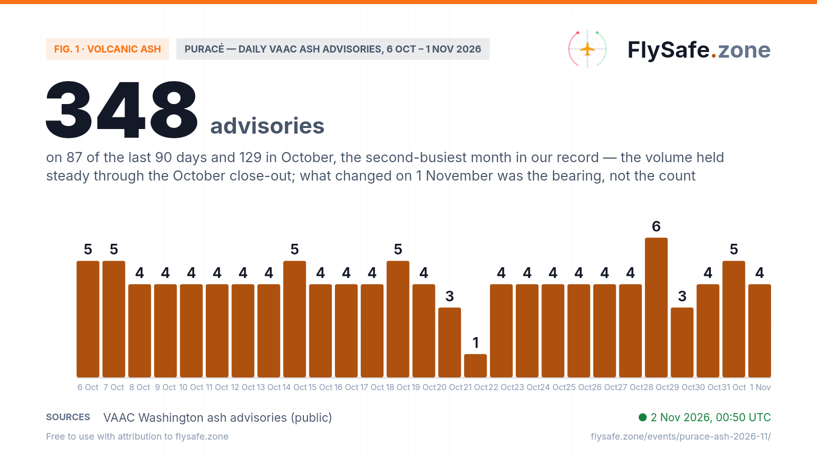
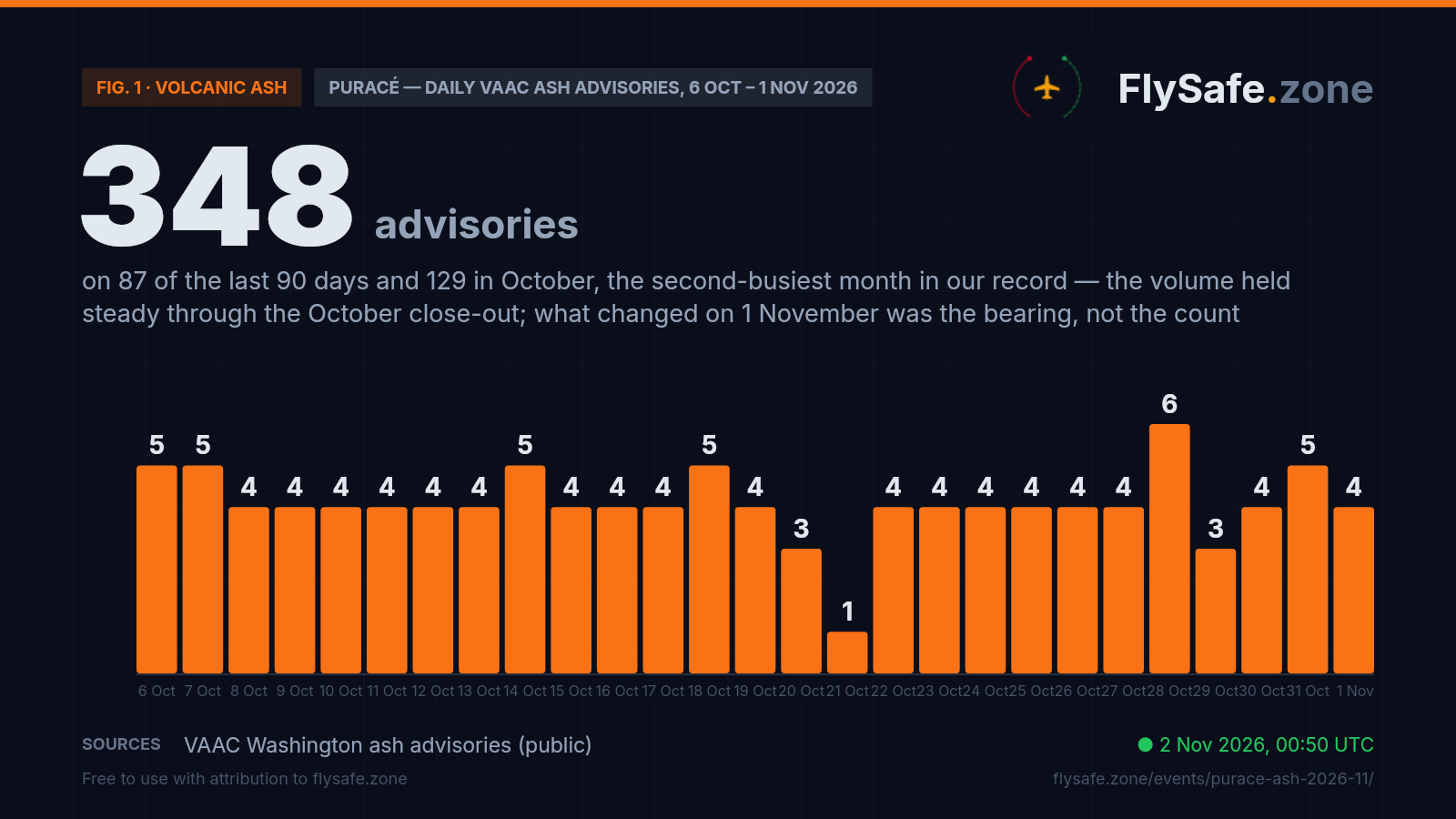
Puracé is a persistent emitter, and this November page does not open on a surge in volume: VAAC Washington has issued 348 ash advisories over the last 90 days, on 87 of those days, and 642 since 12 May across 162 days. That 642 is a floor, not a start — 12 May is when our advisory collection begins, not when Puracé began emitting. By month: 109 in June, 94 in July, 136 in August, 93 in September and 129 in October — the second-busiest month in our record — then four on 1 November, the usual six-hourly rhythm. The sequence has no holes: since the October page closed, advisories run 2026/618 to 2026/691 without a missing number, and the one extra bulletin is a correction re-issued three minutes after the original (28 October, raising the reported top from FL200 to FL210), so the 6 on that bar is not a surge. Two low bars are real quiet, not missing data: 21 October reads 1 because of a 34-hour silence between an 11:38 UTC bulletin on 20 October reporting no ash seen and the next advisory at 21:42 UTC on 21 October — the longest since the 64-hour pause of 23–26 September; VAAC Washington issued 14 and 13 advisories for other volcanoes on those two days, and the Bogotá FIR's ash SIGMETs paused over the same hours, so the quiet was Puracé's, not our feed's. 29 October reads 3 after a shorter 11-hour gap that also followed a no-ash bulletin. One caveat the bulletins carry themselves: of the 69 observed ash areas drawn since 14 October, 60 are flagged as estimated — weather cloud usually hides the summit, and the position and flight level come from the ground observatory's notices, webcam views and model winds. The chart ends with the last complete UTC day. Daily advisory count, 6 October – 1 November:
Fig. 1 — Puracé daily VAAC ash advisory count, VAAC Washington (public) · Data as of 2 Nov 2026, 00:50 UTC · Source: VAAC Washington ash advisories (public).
Airports in the exposure zone
| Airport | Size | Distance from vent | FIR |
|---|---|---|---|
| Guillermo León Valencia (Popayán) (PPN) | small | 29 km · inside the observed ash area by ~0.7 km on the 23:42 UTC 1 Nov advisory (estimated, GND/FL190, drift NW); also inside on 26 Oct 13:53 and 27 Oct 19:08 UTC; 70 of 585 polygon-bearing advisories since 12 May, on 50 days | SKED |
| Gustavo Artunduaga Paredes (Florencia) (FLA) | small | 122 km · outside every observed and forecast ash area on 585 polygon-bearing advisories since 12 May | SKED |
| Alfonso Bonilla Aragón (Cali) (CLO) | large | 136 km · outside every observed and forecast ash area on 585 polygon-bearing advisories since 12 May | SKED |
| Benito Salas (Neiva) (NVA) | small | 141 km · outside every observed and forecast ash area on 585 polygon-bearing advisories since 12 May | SKED |
| Antonio Nariño (Pasto) (PSO) | small | 142 km · outside every observed and forecast ash area on 585 polygon-bearing advisories since 12 May | SKED |
Distance alone does not determine impact — wind direction and the flight levels the ash reaches decide which airports and routes are affected on a given day. FIR = Flight Information Region.
What it means for flights
A November page for an emission that never paused. The October page closed on 14 October on the signal it tracks — whether the drawn ash areas reach Popayán's field — not on the eruption, and the eruption carried on. From 07:09 UTC on 14 October to 23:42 UTC on 1 November VAAC Washington issued 75 Puracé advisories: 69 drew an observed ash area and 6 reported no ash identifiable. Over the same span the observed area missed the field by under 2 km four times — 1.9 km at 11:08 UTC on 15 October, 1.8 km at 03:55 UTC on 18 October, 0.7 km at 03:38 UTC on 22 October and 1.1 km at 14:55 UTC on 23 October — and covered it twice before November: by about 3.8 km at 13:53 UTC on 26 October and 4.5 km at 19:08 UTC on 27 October, each time for a single bulletin. The forecast areas reached the field on 14 of the 75. For a persistent emitter 29 km away, sitting on the edge of the drawn areas is the ordinary state of a north-westerly wind, not an anomaly; what this page tracks is whether that edge turns into a run of consecutive bulletins.
Why 0.7 km is an edge, not a verdict. The 23:42 UTC polygon is a four-point area reaching about 41 km from the vent, drawn without a satellite view of the summit: the bulletin bases it on the observatory's notice of seismic activity, takes the height from past activity and the forecast from model winds. A margin of under a kilometre sits well inside the resolution of that method: the +6-hour forecast area for 05:00 UTC passes about 1 km outside the field, and the +12-hour area for 11:00 UTC puts it about 2.5 km inside. The Bogotá meteorological watch office adopted the same four points for SIGMET 1 (cloud observed at 00:05 UTC, SFC/FL190, moving NW at 10 kt), so the two authorities agree this time rather than sitting a few kilometres apart as they did on 3 October. The practical consequence for a dispatcher is not whether the field is in or out by a few hundred metres but that the airfield is on the edge — the state in which arrival and departure planning, holding fuel and alternates get revisited at every bulletin. That is why we publish the distance to the edge rather than a yes/no exposure flag.
North-west is the heading that reaches the field. Popayán lies on a bearing of about 304° from the summit, and the drift reported in the advisories decides everything else. Of the 69 observed ash areas since 14 October, 30 drifted west, 22 north-west, 10 south-west, three north, three south and one west-south-west — and every one of the three that covered the field was moving north-west. November opened in that sector: puffs seen on satellite moving north-west at 05:20 UTC on 1 November, with all three forecast areas of that bulletin over the field by about 1.3 km, then three more north-westerly bulletins through the day, and both November SIGMETs from Bogotá give the same heading. None of the 30 west-drifting or 10 south-west-drifting areas since 14 October covered the field; while the drift holds north-west, the edge stays over or beside it.
GND/FL190 is the whole band a short-field operation uses. The reported layer runs from the surface to about 19,000 ft. That is not a cruise-level problem — overflights crossing Colombia high above the layer are a separate question — but it spans the entire approach, circuit and initial-climb profile of a regional field 29 km from the vent, plus the low-level airway structure threading the Andes between Popayán, Cali and Neiva. Since 14 October the observed tops have read FL180 on 23 bulletins, FL170 on 19, FL190 on 14, FL200 on 6, FL160 on 4, FL175 on 2 and FL210 once (the 28 October correction). Across the last 90 days they ran FL140 to FL230, most often FL180 or FL170, so the four FL190 readings of 1 November sit at the upper end of the usual band rather than marking a spike.
What the FIR-level numbers do and do not say. Across the Bogotá FIR (SKED), observed en-route traffic ran about 21% below expected over the 24 hours to 00:30 UTC on 2 November. That is a FIR-wide ratio, not an airport count, and it does not read as an ash signal: most of that window predates the 23:42 UTC advisory that put the field inside, Popayán is a small share of the FIR's traffic, and the same measure has ranged from −72% to +57% since 14 October. Its deepest trough — −35%, −72% and −68% on 18, 19 and 20 October — came while the drawn observed areas stayed off the field and was shared by the neighbouring Barranquilla (SKEC) and Lima (SPIM) FIRs on the same days, which points away from Puracé. Our detection layer carries SKED as a volcano-category tracking entry from 26 September onward at low confidence; the notices it picks up are routine taxiway and runway works at Bogotá's El Dorado, not ash notices — a note that the hazard is present, not an airspace event, and nothing like a closure. No ash-related airspace closure is in effect at Popayán or across the FIR in our record.
What we watch next, and what would change this page. Three things would move this story. First, persistence: one bulletin with the field inside the observed area is an edge case; several in a row, or a run of days, is a different operational picture — the stretch from 23 July to 4 August, when the field fell inside the observed area on twelve of those thirteen days, is the closest comparison in our record, and nothing since has come near it. Second, height: reported tops climbing well above the FL190–FL210 seen this autumn, which is what pulls overflights and the wider SKED route structure into the problem. Third, reach: an observed area extending to Cali (CLO) or Neiva (NVA), neither of which has appeared inside any drawn area in our record — or a NOTAM restricting Popayán. The reverse is just as checkable: the August and October pages both closed once the observed areas had stayed off the field over consecutive advisories (38 of them in October), and this page will close on the same test. Automated multi-signal analysis re-checks the advisories, SIGMETs, NOTAMs and FIR-level traffic ratios every three hours, and this page updates from the same cycle. Where the ash sits on any given day, and every go/no-go decision, belongs to operators and the Colombian authorities.
Passenger questions, answered from the data
As of 00:50 UTC on 2 November 2026, the latest VAAC Washington advisory (23:42 UTC, 1 November) draws Puracé's observed ash area, from the surface to FL190, over Guillermo León Valencia (PPN) by about 0.7 km, moving north-west at 10 kt; the Bogotá FIR's SIGMET 1, valid to 06:10 UTC on 2 November, draws the same area. The area is estimated — the summit was under weather cloud — and the next forecast areas move just off the field at 05:00 UTC and back over it at 11:00 UTC. No airspace closure is in effect and no NOTAM for Popayán is in the set we hold. This is a description of the published bulletins, not a safety verdict: go/no-go decisions rest with operators and the authorities. Check your airline's status on the day of travel.
Yes, regularly. Across the 585 Puracé advisories in our record that carry drawn ash polygons — from 12 May 2026 onward — the airport has fallen inside the observed area in 70 of them, on 50 separate days: ten days in May, ten in June, eleven in July, nine in August, five in September, four in October and one so far in November. The longest run was from 23 July to 4 August, inside on twelve of those thirteen days. Puracé is a persistent emitter 29 km from the field, so which way the wind blows decides whether the plume is over the airfield or over empty mountains on any given day.
We cannot tell you that, and nobody outside your airline can. What we can say is what the published bulletins show: the field sits on the edge of the drawn ash area, the forecast areas move on and off it through 2 November, no airspace closure is in effect and no NOTAM restricts Popayán in the set we hold. Airlines decide case by case from the same advisories and SIGMETs, usually close to departure, so the most useful step is to check your airline's flight status on the day and keep your contact details up to date in your booking.
Cali's Alfonso Bonilla Aragón (CLO), 136 km from the vent, has fallen inside none of the observed or forecast ash areas drawn on 585 polygon-bearing advisories in our record, and neither have Neiva, Pasto or Florencia. Across the Bogotá FIR (SKED) as a whole, observed en-route traffic ran about 21% below expected over the 24 hours to 00:30 UTC on 2 November; that measure has swung between −72% and +57% since mid-October, its deepest dip shared with neighbouring FIRs, so it is a FIR-wide ratio our data does not tie to the ash.
It is a persistent emitter: near-continuous low-intensity ash emission rather than discrete eruptions. VAAC Washington re-issues advisories roughly every six hours while emission continues — 348 advisories over the last 90 days, on 87 of those days, 129 in October alone, and 642 since our record opens on 12 May 2026. Quiet stretches happen: the latest was a 34-hour silence between 20 and 21 October.
Aircraft do not fly through reported ash — dispatchers plan around the advisory and SIGMET areas, and regulators restrict or close airspace when ash reaches it. We publish the measured picture: the advisory cadence, the reported flight levels, the drift direction and how far each airport sits inside or outside the drawn areas. Routing and go/no-go decisions belong to the operators and the Colombian authorities.
For media — the full kit
Everything on this page — charts, CSV, quotes — is published under CC BY 4.0: free to reuse with attribution to FlySafe.zone. Charts come in dark (social/web) and light (print/light layouts) versions; attribution and license are embedded in every file.
“VAAC Washington's 23:42 UTC advisory on 1 November 2026 drew Puracé's observed ash area, from the ground to FL190, over Popayán's Guillermo León Valencia airport 29 km from the vent by about 0.7 km — the third time since mid-October and the 70th of 585 polygon-bearing advisories since mid-May — while the volcano kept up its six-hourly advisories, 129 of them in October, and Cali's airport has appeared in none of the drawn ash areas, according to flight-monitoring service FlySafe.zone.”
Boilerplate — about the source (for your article footer)
FlySafe.zone monitors airspace risk and observed airport activity worldwide: 334 flight-information regions scored daily, GPS-interference signals, volcanic-ash exposure and daily observed movements at 493 airports from the crowdsourced ADS-B receiver network. Methodology: flysafe.zone/methodology.
Need a different cut of the data, a comment, or numbers for another airport? Leave an email — we answer fast during active events.